GVO MARINE ELECTRONICS-Fresh & Saltwater
MARINE ELECTRONICS FOR FRESH & SALTWATER: We Have Fishfinders and Accesories-GPS-Radios Ice Fishing-Trolling Motors-Fishing Charts & Maps-Parts- Lowrance- Garmin-Humminbird-Icom-Uniden- Standard Horizon and More
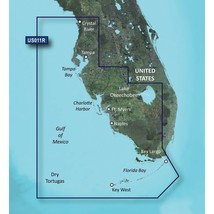
GARMIN BLUECHART® G3 VISION® HD - VUS011R - SOUTHWEST FLORIDA - MICROSD™/SD™
$319.00
DISCOUNTS
This item has been added to your cart
 GARMIN BLUECHART® G3 VISION® HD - VUS011R - SOUTHWEST FLORIDA - MICROSD™/SD™ added to cart.
Only one available in stock
GARMIN BLUECHART® G3 VISION® HD - VUS011R - SOUTHWEST FLORIDA - MICROSD™/SD™ added to cart.
Only one available in stock
View Cart or continue shopping.
 Please wait while we finish adding this item to your cart.

1
of
11
Item details
Condition
New
Brand
Garmin
Model
30367
MPN
010-C0712-00
Sport/Activity
Fishing
Indoor/Outdoor
Outdoor
Type
BlueChart® g3 Vision® HD
Manufacturer Warranty
Please contact the manufacturer directly with any issues or conce
Features
Auto Guidance¹ technology, High-resolution relief shading
UPC
753759068929
About this item
GVO Marine Electronics:
We provide reliable, safe online shopping 24 hours a day, 7 days a week throughout the U.S. and the world. We are strongly committed to providing our customers with top quality merchandise and world class service.
Model 30367
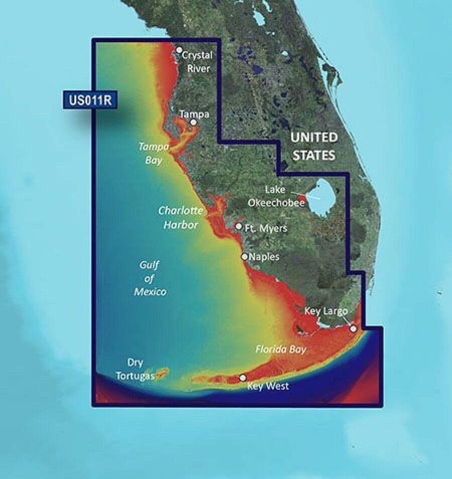
BlueChart® g3 Vision® HD - VUS011R - Southwest Florida - microSD™/SD™
Coverage:
Crystal River through Key Largo, including Tampa Bay, Ft. Myers, Lake Okeechobee, Florida Bay, Key West, and the Dry Tortugas.
Premier Coastal Navigation Charts
- Provides industry-leading coverage, clarity and detail with updated coastal charts that feature integrated Garmin and Navionics® data
- Auto Guidance¹ technology uses your desired depth and overhead clearance to calculate routes and show a suggested path to follow
- High-resolution relief shading combines color and shadow to give you an easy-to-interpret, clearer view of bottom structure than contour lines alone
- Depth Range Shading provides up to 10 depth ranges, enabling you to view your target depth at a glance
- Up to 1’ contours provide a more accurate depiction of the bottom structure for improved fishing charts and navigation in swamps, canals and marinas
Experience unparalleled coverage and brilliant detail on the water. BlueChart g3 Vision coastal charts provide industry-leading coverage, clarity and detail with integrated Garmin and Navionics data, Auto Guidance technology and high-resolution relief shading..
Auto Guidance Technology
The Auto Guidance feature¹ uses your desired depth and overhead clearance to calculate a route and a suggested path to follow.
High-resolution Relief Shading Feature
High-resolution relief shading combines color and shadow to give you an easy-to-interpret, clearer view of bottom structure than contour lines alone.
Up to 1’ Contours
The closer the contour lines, the more accurate the depiction of the bottom structure for improved fishing charts and navigation in swamps, canals and marinas.
NOAA Raster Cartography
If you prefer your display to have the look of paper charts, NOAA raster cartography2 is available as a free downloadable feature via the ActiveCaptain® app.
Depth Range Shading
This feature provides up to 10 depth ranges, enabling you to view your target depth at a glance.
Shallow Water Shading
This feature allows you to use shading to designate the shallow water depths you need to avoid.
High-resolution Satellite Imagery
These detailed images of ports, marinas, bridges and navigational landmarks help provide you with superior situational awareness.
Unique 3-D Views
MarinerEye and FishEye views provide additional perspective both above and below the water line.
¹Auto Guidance is for planning purposes only and does not replace safe navigation operations
²Raster cartography cannot be viewed on echoMAP CHIRP and ECHOMAP Plus combos but can be viewed on mobile devices via the ActiveCaptain mobile app
THIS ITEM CAN NOT BE RETRUNED TO THE ORIGINAL POINT OF PURCHAS. PLEASE CONTACT GARMIN DIRECTLY WITH ANY ISSUES OR CONCERNS.
GVO Marine Electronics: .
Get the item you ordered or get your money back.
Covers your purchase price and original shipping.
GVO Marine Electronics:
We provide reliable, safe online shopping 24 hours a day, 7 days a week throughout the U.S. and the world. We are strongly committed to providing our customers with top quality merchandise and world class service.
Model 30367
BlueChart® g3 Vision® HD - VUS011R - Southwest Florida - microSD™/SD™
Coverage:
Crystal River through Key Largo, including Tampa Bay, Ft. Myers, Lake Okeechobee, Florida Bay, Key West, and the Dry Tortugas.
Premier Coastal Navigation Charts
- Provides industry-leading coverage, clarity and detail with updated coastal charts that feature integrated Garmin and Navionics® data
- Auto Guidance¹ technology uses your desired depth and overhead clearance to calculate routes and show a suggested path to follow
- High-resolution relief shading combines color and shadow to give you an easy-to-interpret, clearer view of bottom structure than contour lines alone
- Depth Range Shading provides up to 10 depth ranges, enabling you to view your target depth at a glance
- Up to 1’ contours provide a more accurate depiction of the bottom structure for improved fishing charts and navigation in swamps, canals and marinas
Experience unparalleled coverage and brilliant detail on the water. BlueChart g3 Vision coastal charts provide industry-leading coverage, clarity and detail with integrated Garmin and Navionics data, Auto Guidance technology and high-resolution relief shading..
Auto Guidance Technology
The Auto Guidance feature¹ uses your desired depth and overhead clearance to calculate a route and a suggested path to follow.
High-resolution Relief Shading Feature
High-resolution relief shading combines color and shadow to give you an easy-to-interpret, clearer view of bottom structure than contour lines alone.
Up to 1’ Contours
The closer the contour lines, the more accurate the depiction of the bottom structure for improved fishing charts and navigation in swamps, canals and marinas.
NOAA Raster Cartography
If you prefer your display to have the look of paper charts, NOAA raster cartography2 is available as a free downloadable feature via the ActiveCaptain® app.
Depth Range Shading
This feature provides up to 10 depth ranges, enabling you to view your target depth at a glance.
Shallow Water Shading
This feature allows you to use shading to designate the shallow water depths you need to avoid.
High-resolution Satellite Imagery
These detailed images of ports, marinas, bridges and navigational landmarks help provide you with superior situational awareness.
Unique 3-D Views
MarinerEye and FishEye views provide additional perspective both above and below the water line.
¹Auto Guidance is for planning purposes only and does not replace safe navigation operations
²Raster cartography cannot be viewed on echoMAP CHIRP and ECHOMAP Plus combos but can be viewed on mobile devices via the ActiveCaptain mobile app
THIS ITEM CAN NOT BE RETRUNED TO THE ORIGINAL POINT OF PURCHAS. PLEASE CONTACT GARMIN DIRECTLY WITH ANY ISSUES OR CONCERNS.
GVO Marine Electronics: .
| Get the item you ordered or get your money back. |
| Covers your purchase price and original shipping. |